When Property Boundaries and Ownership Records Become Essential: Understanding the Index Map Search
Property transactions, planning applications, and boundary disputes often hinge on one crucial question: what does the official record actually show about a specific piece of land? In England and Wales, this fundamental inquiry leads directly to HM Land Registry's index map search, a formal procedure that reveals whether land is registered and, if so, provides the vital title number that unlocks the complete property record.
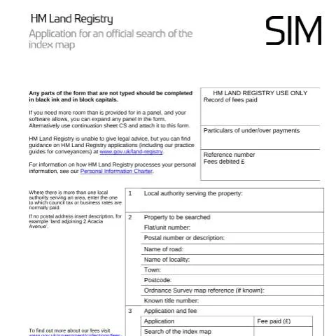
The Index map: application for an official search (SIM) serves as the gateway to this information, offering a definitive answer about registration status before parties commit to more expensive searches or legal procedures. Unlike informal online checks, this official search carries legal weight and provides certificated results that courts, lenders, and professional advisors will accept without question.
Understanding when and how to deploy this search can save considerable time, money, and legal complications. Whether you're a conveyancer investigating a complex boundary issue, a developer assessing multiple plots, or a homeowner facing a neighbour dispute, the index map search often represents the logical starting point for any serious property investigation.
The Registration Landscape: Why Index Map Searches Matter in Modern Property Law
The current system of land registration in England and Wales has evolved significantly since the Land Registration Act 2002 came into force. This legislation aimed to create a comprehensive, reliable register of land ownership, but the transition remains incomplete. Approximately 85% of land in England and Wales is now registered, leaving substantial areas where ownership relies on older deeds and documents rather than the modern registered system.
This mixed landscape creates practical challenges for anyone dealing with property. The index map maintained by HM Land Registry acts as the definitive reference point, showing the precise boundaries of registered land and assigning each parcel a unique title number. However, the map also reveals gaps – areas of unregistered land where different rules and procedures apply.
The index map search becomes particularly crucial in several scenarios:
- Rural and semi-rural properties where registration may be patchy and boundaries unclear
- Development sites where multiple ownerships may exist within a single area
- Historical properties that may have been subdivided over time
- Land near public highways where highway boundaries can be complex
- Areas with common land or manorial rights that may not appear on standard property searches
Professional conveyancers and property lawyers increasingly rely on index map searches to establish the foundation of their investigations. The search provides certainty about what is registered, what isn't, and where the official boundaries lie according to HM Land Registry's records.
Who Initiates Index Map Searches and in What Circumstances
The SIM form accommodates a diverse range of applicants, each with distinct motivations and requirements. Professional users – solicitors, licensed conveyancers, and surveyers – represent the largest category, often conducting searches as part of broader transaction or dispute resolution processes. These professionals typically hold key numbers with HM Land Registry, allowing streamlined processing and direct debit arrangements.
However, the system remains accessible to private individuals who may need official confirmation of registration status. Property owners facing boundary disputes frequently initiate these searches to establish the precise extent of their registered title compared to neighbouring land. Similarly, prospective purchasers sometimes conduct preliminary index map searches before engaging professional help, particularly for unusual or complex properties.
Local authorities and statutory bodies represent another significant user group. Planning departments may require index map searches when assessing applications that affect multiple properties or unclear boundaries. Highways authorities use these searches when considering compulsory purchase or road improvement schemes. Environmental agencies may need to establish land ownership patterns for contamination or flooding issues.
Specific Professional Applications
Different professional contexts generate distinct search requirements:
| Professional Context | Typical Search Motivation | Key Information Required |
|---|---|---|
| Conveyancing Transaction | Verify property boundaries match contract description | Title numbers, registered extent, unregistered areas |
| Boundary Dispute | Establish official registered boundaries | Precise boundary positions, neighbouring titles |
| Development Planning | Identify all affected ownerships | Multiple title numbers, unregistered land, access rights |
| Mortgage Lending | Confirm security property extent | Complete title coverage, boundary certainty |
The timing of index map searches often proves critical. Conducting searches too early may result in information becoming outdated before completion, while leaving searches too late can delay transactions or legal proceedings. Most professionals balance these considerations by integrating index map searches into their standard procedure timelines.
Navigating the SIM Form: Technical Requirements and Practical Considerations
The SIM form's structure reflects HM Land Registry's emphasis on precision and legal certainty. Each panel serves a specific purpose in ensuring the search request can be processed accurately and the results delivered to the correct recipient.
Panel 1 – Local Authority Identification requires careful attention, particularly in areas where multiple councils may have jurisdiction. The instruction specifies "where there is more than one local authority serving an area, enter the one to which council tax or business rates are normally paid." This seemingly straightforward requirement can become complex in boundary areas where different councils handle different services, or where recent local government reorganisation has created overlapping responsibilities.
Panel 2 – Property Description demands the most detailed attention. The form accommodates both postal addresses and descriptive references for land without conventional addresses. For properties with established postal addresses, completeness is essential – missing elements like flat numbers or locality names can result in searches covering incorrect areas or failing entirely. For land without postal addresses, the descriptive approach requires sufficient detail to enable unambiguous identification on Ordnance Survey mapping.
The Ordnance Survey map reference field, while marked as optional, can significantly improve search accuracy, particularly for rural or development land. Modern GPS systems and online mapping tools make obtaining these references relatively straightforward, and their inclusion often prevents delays or clarification requests from HM Land Registry.
Fee Structure and Payment Methods
Current fee arrangements reflect HM Land Registry's move towards digital efficiency while maintaining accessibility for all users. The standard search fee applies regardless of whether the land proves to be registered or unregistered – the search itself has value in providing definitive information about registration status.
Professional users benefit from streamlined payment arrangements through key number accounts and direct debit agreements. These arrangements not only expedite processing but also provide detailed transaction records that assist with client billing and accounting procedures. Individual applicants typically pay by cheque, though the form's design anticipates future expansion of payment methods.
Fee calculation can become complex for searches covering multiple discrete areas or properties. HM Land Registry's approach generally treats each separately identifiable piece of land as requiring a separate search, though contiguous areas under single ownership may qualify for combined treatment in some circumstances.
The Search Process: From Submission to Certificate
Once submitted, the SIM form initiates a systematic examination process within HM Land Registry's regional offices. The process begins with administrative validation – checking that all required fields are complete, fees are correct, and any attached plans meet technical standards. Forms failing these initial checks typically receive rapid rejection with clear explanations of deficiencies.
Successful applications proceed to technical examination, where HM Land Registry staff examine the index map to identify all registered titles affecting the specified area. This examination requires considerable skill, particularly for complex areas where multiple titles may have overlapping or adjacent boundaries. The examining officer must also identify any unregistered areas within the search zone and note these clearly in the final certificate.
Plan Requirements and Accuracy often determine processing speed and success. The form's guidance emphasises that attached plans must contain "sufficient details of the surrounding roads and other features to enable the land to be identified satisfactorily on the Ordnance Survey map." Plans lacking adequate context or showing insufficient detail frequently generate requests for clarification, delaying the search result.
Modern practice increasingly favours digital plan submission where possible, as these typically offer better clarity and can be more easily cross-referenced against HM Land Registry's digital mapping systems. However, hand-drawn plans remain acceptable provided they meet accuracy and detail requirements.
Certificate Content and Legal Status
The resulting certificate carries significant legal weight, providing official confirmation of the search results. Certificates typically identify:
- Registered titles affecting the search area, with complete title numbers
- Unregistered areas within the search zone
- Boundary relationships between different titles
- Any mapping discrepancies or uncertainties
The certificate's legal status means it can be relied upon for transaction purposes, court proceedings, and professional advice. However, it represents the position as at the search date – subsequent registrations or boundary changes will not be reflected unless further searches are conducted.
Digital Delivery and Modern Communication Preferences
HM Land Registry's transition towards digital service delivery significantly affects how search results are issued and received. Panel 5 of the SIM form addresses this transition, though current arrangements remain in flux as the organisation develops its electronic delivery capabilities.
The form's current approach requires applicants to actively opt for paper delivery if they provide an email address but prefer physical documents. This default towards electronic delivery reflects both efficiency considerations and environmental policy, but recognises that some users may have specific requirements for paper certificates – perhaps for court proceedings or client presentation purposes.
Professional users increasingly favour electronic delivery for speed and convenience, particularly when conducting multiple searches for complex transactions. Electronic certificates can be received within hours rather than days, and can be easily forwarded to clients or other professionals involved in transactions. However, some situations still favour paper delivery – for example, when certificates must be exhibited in court proceedings or stored in physical property files.
The transition period creates some uncertainty about delivery methods and timing. HM Land Registry's practice guides provide the most current information about electronic delivery availability, and these should be consulted before assuming electronic delivery will be available for any particular application.
Complex Scenarios: Multi-Title Searches and Boundary Investigations
Real-world property situations often extend beyond simple single-title searches, requiring sophisticated approaches to index map investigation. Development sites frequently involve multiple existing titles that may need to be assembled or subdivided, creating complex search requirements. In such cases, a single SIM application may need to cover an extensive area, potentially revealing numerous separate titles with different ownership histories and boundary arrangements.
The challenge intensifies when dealing with historical subdivisions where original larger properties have been split over time. Index map searches may reveal that what appears to be a single property actually comprises multiple registered titles, each with separate ownership and potentially different restrictions or rights. Conversely, what appears to be multiple properties may prove to share a single title number, indicating common ownership despite separate occupations.
Boundary dispute scenarios present particular complexities for index map searches. Disputes often arise precisely because the ground position differs from registered boundaries, or because different parties interpret boundary features differently. An index map search provides the official registered position, but this may not resolve the dispute if the registration itself is inaccurate or if rights exist that are not reflected in the register.
Rural Land and Agricultural Holdings
Agricultural and rural contexts create specific challenges for index map searches. Large rural estates may have complex registration patterns reflecting historical management practices, with some areas registered and others remaining unregistered. Agricultural tenancies add further complexity, as the index map search reveals only ownership, not occupation or tenancy arrangements.
Common land, village greens, and public rights of way may appear on index maps but with special notations reflecting their particular status. These areas require careful interpretation, as standard ownership concepts may not apply in the usual way. Professional users dealing with rural properties typically supplement index map searches with additional investigations into commons registrations and public rights.
Quality Assurance and Dispute Resolution Mechanisms
The accuracy of index map searches depends on the underlying quality of HM Land Registry's mapping and registration data. While generally reliable, the system acknowledges that errors can occur, particularly in areas where registration is complex or where historical mapping may be imprecise. The Land Registration Act 2002 provides mechanisms for correcting errors, but these can take time to implement and may not help users who have already relied on incorrect information.
Mapping discrepancies represent a common source of difficulty. The index map is based on Ordnance Survey mapping, but property boundaries may not align perfectly with OS map features. Where discrepancies exist, HM Land Registry typically notes these on certificates, but resolution may require detailed boundary investigations or formal determination procedures.
Users who believe search results contain errors can challenge these through HM Land Registry's complaints and dispute procedures. However, distinguishing between mapping errors and legitimate boundary uncertainty often requires expert interpretation. Professional users typically advise clients about these limitations when presenting search results.
The indemnity provisions of the Land Registration Act 2002 provide some protection for users who suffer loss due to registry errors, but claiming indemnity requires demonstrating that loss resulted from registry mistakes rather than inherent property complications or user misinterpretation.
Prevention remains better than cure, and experienced users often supplement index map searches with additional investigations – examining filed plans in detail, checking for pending applications that may affect boundaries, and considering whether the search area should be expanded to capture potentially relevant neighbouring titles. This comprehensive approach, while more expensive initially, often prevents costly complications during later transaction or dispute resolution stages.