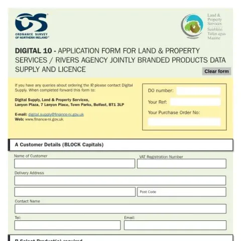
Understanding the Digital 10 Application Form for Land & Property Services and Rivers Agency
The Digital 10 form is an official application document issued by the Department of Finance Northern Ireland. It serves as a formal request for licensing and data supply related to jointly branded products developed by Land & Property Services (LPS) and the Rivers Agency. This form is primarily intended for organisations or individuals seeking access to specific geospatial data and flood mapping products for internal business use.
Purpose and Scope of the Digital 10 Form
The main objective of the Digital 10 application form is to facilitate the licensing process for digital data sets, which include flood maps, river models, and enhanced river centreline data. These data products are essential for organisations involved in flood risk management, urban planning, environmental assessments, and related fields. The form ensures that applicants clearly specify their data requirements, enabling the Department of Finance Northern Ireland to grant appropriate licences for internal use only.
Who Should Complete the Form?
This application is designed for entities that require access to detailed geospatial data for operational purposes. Typical applicants include local authorities, environmental consultants, civil engineers, and other professional bodies involved in flood risk analysis, land development, or infrastructure projects. The form is not intended for commercial publishing or broader public dissemination without prior approval.
How to Fill Out the Application
Completing the Digital 10 form involves providing comprehensive details about the applicant and specifying the data products needed. The form is divided into sections:
- Part A: Customer Details – includes the organisation’s name, delivery address, contact person, telephone number, and email address.
- Part B: Product Selection – requires applicants to select the specific data products they wish to licence. These include various flood maps (e.g., floodplain, tidal, surface water), flood hazard models, historical flooding data, and enhanced river centreline datasets.
Applicants must clearly tick the boxes corresponding to their required products and specify any particular models or coverage areas if applicable. Accurate completion ensures prompt processing and appropriate licensing arrangements.
Supporting Documents and Data Requirements
Unlike some applications, the Digital 10 form does not typically require additional documentation at the initial stage. However, applicants should be prepared to provide further information or clarification if requested by Digital Supply. The data products requested will be supplied in specified formats, such as ArcGIS File Geodatabase or InfoWorks ICM databases, depending on the product selected.
Submission Process and Contact Details
Once completed, the form must be forwarded to the Digital Supply team at the Department of Finance Northern Ireland. The postal address is:
Lanyon Plaza, 7 Lanyon Place, Town Parks, Belfast, BT1 3LP
Alternatively, applicants can send the form via email to: [email protected]. For further assistance or queries about the licensing process, applicants are encouraged to contact the Digital Supply team directly.
Fill in your form directly online
No printing: type your details into the boxes of the official form, tick, then download the PDF ready to send.
- 1Type into the form boxes
- 2Tick in one click
- 3Save and download the PDF
Common Errors to Avoid When Completing the Form
- Incomplete or inaccurate contact details: Ensure all fields, including email and telephone numbers, are correct to facilitate communication.
- Incorrect product selection: Carefully review the available data products and tick only those relevant to your project to avoid delays.
- Omission of specific coverage areas or model details: Clarify if you require full coverage or specific models, especially for premium flood maps.
- Failure to sign and date the form: An unsigned or undated application may be rejected or delayed.
Legal and Licensing Conditions
The Digital 10 form includes a section where applicants must acknowledge and accept the licensing terms. The licence permits use of the data solely for internal business activities, and any external publication or commercial use requires additional permissions. It is essential to review the intellectual property licensing terms carefully before submitting the application.
By submitting the Digital 10 form, applicants agree to abide by the conditions set out by the Department of Finance Northern Ireland, ensuring responsible and lawful use of the licensed geospatial data products.